The Aymara people gave this narrow strip of land squeezed between the Andes to the East and the Pacific Ocean to the west the name “Chile“, meaning “the land lost in the sea”. Full of unusual places, surprises, and contrasts it stretches over 2,670 miles between latitudes 17 and 56, but only 217 miles from east to west at its widest point. From south to north, the country unfolds in an astonishing variety of landscapes and climates, each region abounding in natural and cultural treasures. In the south the land is wild and hostile and yet displays beautiful landscapes: glaciers, sharp peaks, lakes with turquoise blue water, night, marine… Welcome to Torres del Paine National Park, this beautiful wilderness attracts thousands of hikers every year looking for open spaces and adventure. The park is considered as one of the most beautiful natural parks in South America. A jewel of nature in southern Chile, it combines glaciers and Andean lakes, forests and Patagonian steppes… no wonder it is a popular destination with over 100,000 visitors per year. Chile is a land of extremes with something to delight all nature enthusiasts !

The Última Esperanza Sound
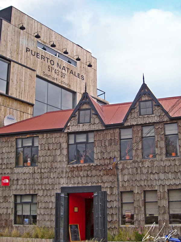
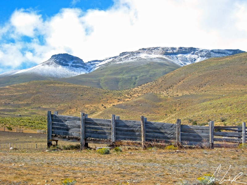
Puerto Natales is a small fishing port located 1,854 miles south of the Chilean capital Santiago and 153 miles northwest of Punta Arenas on the Señoret channel between the opening of the Última Esperanza Sound and the Andes mountains. It is the starting base for treks and excursions to the Balmaceda and Serrano glaciers (by boat) and also a gateway to the world-renowned Torres del Paine National Park. The park is located about 70 miles from Puerto Natales and 193 miles north of Punta Arenas. Puerto Natales is the capital of the province of Última Esperanza (Last Hope) in Tierra del Fuego, and its colorful houses give it an old-fashioned charm. Puerto Natales knew its golden age at the time of the large estancias and before the opening of the Panama Canal in 1914 when boats sailing between the Pacific and the Atlantic stopped for provisions. Few visitors take the time to wander the streets of this picturesque town because they want to hit the road to the park… Asphalt quickly gives way to gravel… If Puerto Natales is the nearest town to the main entrance of Sarmiento, there is still more than 100 miles of unpaved road ahead of us ! Sumptuous scenery unfolds before our eyes. One by one peaceful green landscapes, summits sprinkled with snow, and lakes with azure reflections appear… and then at the end of the rocky road, the clouds tear apart and we have our first glimpse of the peaks of the Paine massif. “Paine” means “blue” in the Aónikenk language of the Tehuelche Indians. This group of nomads lived in southern Patagonia between the Santa Cruz River and the Strait of Magellan. The first European explorers (including Antonio Pigafetta, chronicler of the journey of Magellan in 1520) to encounter the Tehuelche Indians named them “patagones” and forged the legend of the giants of Patagonia.

Torres del Paine National Park
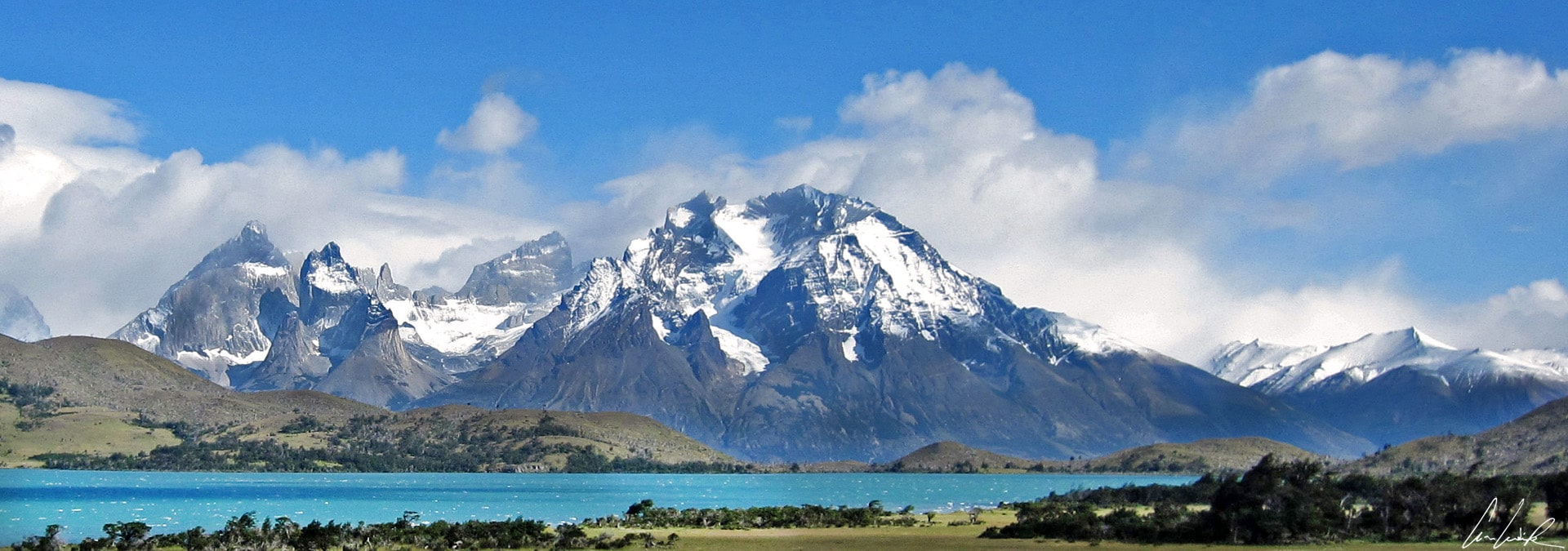
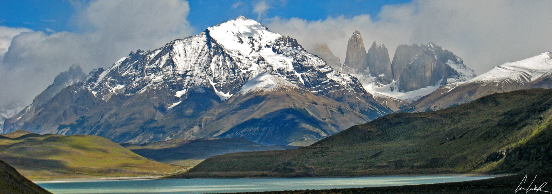
The park covers 448,280 acres or 701 square miles and is one of the largest in Chile. It stretches 62 miles from north to south and 43 miles from east to west. It was established in 1959 as Parque Nacional de Turismo Lago Grey (Grey Lake National Tourism Park), and the present name was given in 1970. In 1978, it was designed a World Biosphere Reserve by UNESCO. It owes its name to the three distinctive granite peaks of the Paine mountain range. The highest, “Torres”, the Cerro Paine Grande culminates at 9,462 feet above sea level. The Paine Massif is small but of great beauty: spectacular silhouettes, sharp edges, different rock colors, overhanging walls make this mountainous group one of the most amazing in the world! The Monte Almirante Nieto at the center of the photo appears small as it is surrounded by the famous Cuernos del Paine on the left and the famous Torres del Paine on the right. Monte Almirante Nieto passes unnoticed by many of the park’s “visitors”… This imposing summit, located in the Ascencio Valley, which is named after Ascencio Brunel a legendary outlaw captured in the park in 1902, culminates at 8,100 feet. It is favored by climbers because its ascent is less difficult than that of its close neighbors. Some of the flanks of the Almirante Nieto are still unspoiled ! The peaks of Cuernos del Paine are almost always visible wherever you are in the park. These three spiky granite peaks are easily identifiable by their color and their horn-like shape, “Cuernos”. The dark top consists of a black sedimentary layer while the rock below is lighter. The Cuerno Principal stands at an altitude of 8,071 feet, Cuerno Norte is 7,415 feet, and Cuerno Este is 6,561 feet high. Although the Paine Massif is beautiful, bad weather and unstable glaciers discourage climbers… And of those who could not restrain their aspirations to reach Cerro Plaine’s summit, many lost their lives in the attempt.

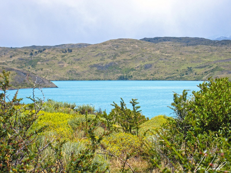
Torres del Paine: Lago Pehoé with its turquoise waters
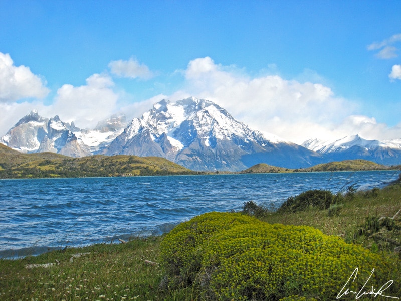
The lakes in the park take on a turquoise, emerald or milky color depending on their depth, the composition of the water, and the weather. Many lakes are in fact salt lagoons. One example is Lago Sarmiento. It covers an area of 35 square miles, measuring 14 miles long and 3.7 miles wide with a maximum of 1,033 feet deep. It was named for the explorer, humanist and historian Pedro Sarmiento of Gamboa (1532-1592). One mile from the north-west edge of Lago Sarmiento is Lago Nordenskjöld (for good pronunciation, you should have your mouth full of krisp… krisprolls… the famous Swedish buns). It covers 11 square miles with a maximum length of 9.3 miles. It was named after the Swedish explorer and geologist Otto Nordenskjöld who discovered it at the beginning of the 20th century. Lago Nordenskjöld is connected to Lago Pehoé by Salto Grande, a 213 foot high waterfall. On the lake shore, we have finally a glimpse of the famous Torres piercing the white clouds at their summits. The clouds gradually fade; some shy sunbeams pierce their way through the mists revealing a magical landscape… ephemeral, this breakthrough is brief ! We have been warned that the climate of Patagonia unpredictable and capricious, alternating at times between bursts of sunlight, strong winds, and torrential rains… Finally, we have seen these breathtaking Torres with our own eyes and not just on the Chilean 1000 peso note ! The Lago Nordenskjöld is surrounded by abundant vegetation and wildlife, including guanacos grazing along the lakeshore and ignoring passing hikers… With its turquoise waters surrounded by lush vegetation and a superb view of the Cuernos del Paine, Lago Pehoé, covering 8.5 square miles, offers one of the most beautiful landscapes in the park when the weather permits, given the high rainfall of the region. Under a clear sky, the crystalline waters reflecting the Cuernos del Paine give it an incredible beauty, but time and again, these peaks are enveloped in mists or long-lasting clouds to the disappointment of visitors… and passionate photographers. And here we are, at the edge of the lagoon, open-mouthed at first because of the cold, but also because of the surpassing beauty of the place! The word “Pehoé,” which means “hidden” in the Tehuelche Indian language, describes the lake surrounded by mountains and hills and protected from sight. Continuing our way, we reach the Lago Gray, whose name seems to come from its grayish color caused by sediment in the water. Covering an area of 12.6 square miles, Gray Lake is fed by the vast Glacier Gray, the largest glacier in the park. This glacier covers an area of approximately 100 square miles and is 17 miles long by 4 miles wide and about 98 feet thick. The lake and its lagoon are swept by wind gusts so violent that it is sometimes difficult to maintain one’s balance. Cold water drops fly off the lake and hit your face !

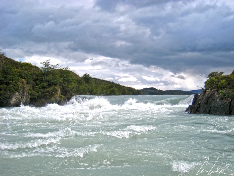
Serrano Glacier
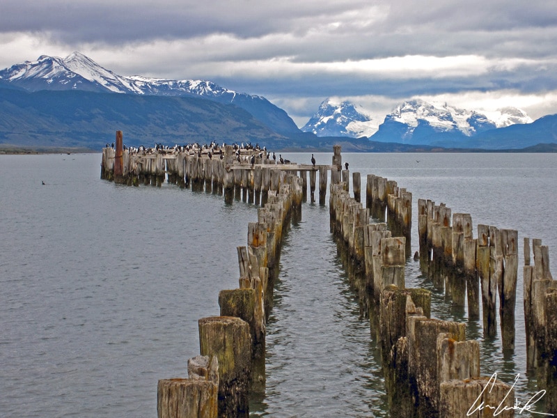
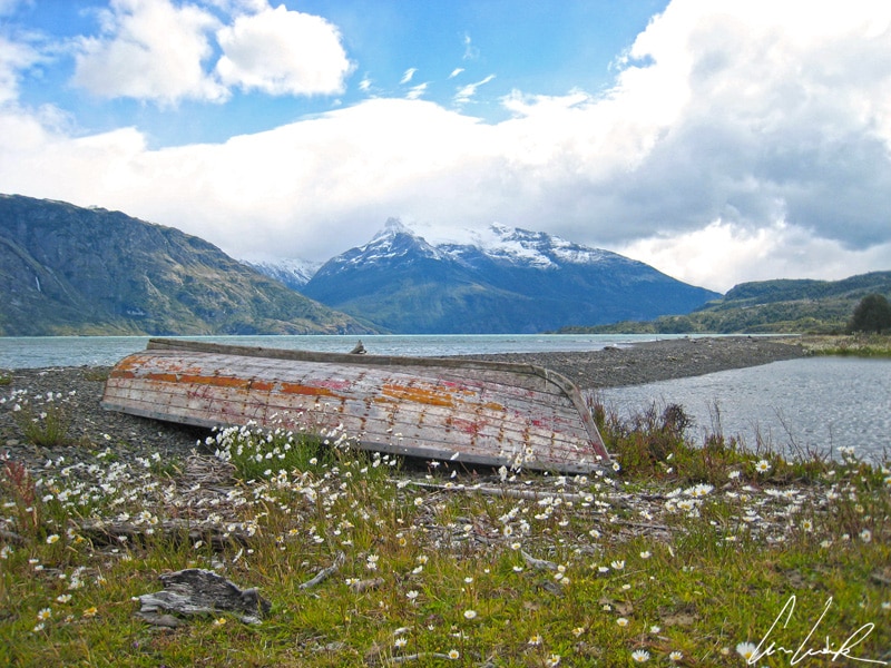
We sail on a zodiac on the Rio Serrano up to the Bernardo O’Higgins National Park well-known for its two magnificent glaciers, Balmaceda and Serrano. The park is named after Bernardo O’Higgins Riquelme, a military leader during Chile’s fight for independence and then the new nation’s first head of state. The Serrano River is fed by Lake Toro, the biggest lake in the region, which is in turn fed by glaciers. The river continues its course to reach the fjord Última Esperanza, whose waters extend to the Pacific Ocean. For the full enjoyment of our adventure, we put on warm clothes, gloves, hats, and lifejackets for our journey on the glacier-fed river… right up to the foot of the glaciers Balmaceda and Serrano, both parts of the southern Ice field. Patagonian weather accompanies us: wind, crazy cold, and gray clouds enveloping the snow-capped peaks. But no matter, we are well wrapped up to withstand the capricious weather of southern Patagonia ! The zodiac ride goes through varied landscapes, alluvial plains carved by wind and floods, waterfalls, dense forests that seem impenetrable and mysterious from the river, small barren islands, tumultuous white water… After unforgettable scenery, we reach the Serrano glacier… A short hike through a dense forest of coihues and ñirres takes us to the foot of the Serrano glacier drowned in mist and silence. The landscape seems austere: the glacier descends between rock walls, the blue-white color of the ice contrasting with the charcoa- colored rocks, accentuating the harshness of the place. Blocks of ice in various shapes break off from the vertical walls and fall with a splash into the gemlike radiant blue of Lake Serrano, offering an impressive show of Mother Nature’s power. The ephemeral art of nature… Most adventurers take a small zodiac ride along icebergs to get as close as possible to the huge wall of ice, “Ohé, ohé, capitaine abandonné / Ohé, ohé, mets des ailes à ton voilier / Sonnez, sonnez, les sirènes au vent salé / Sonnez, sonnez la dernière traversée ” (Hey, oh, Captain Abandoned / Hey, oh, hey oh, lift the wings on your sailboat / Ring, ring the sirens of the salty wind / Ring, ring the sirens for the last crossing.) (Capitaine abandonné – Gold).

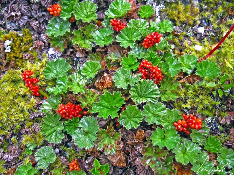
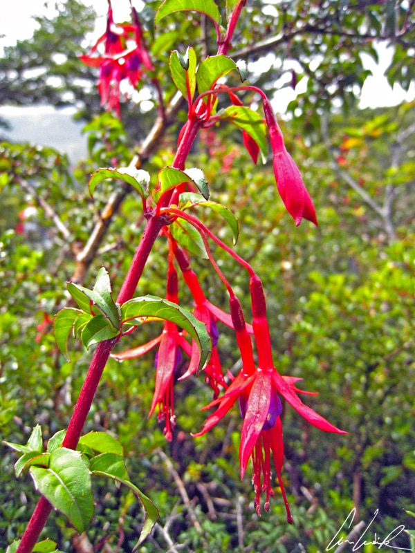
Murtilla or Chilean Guava
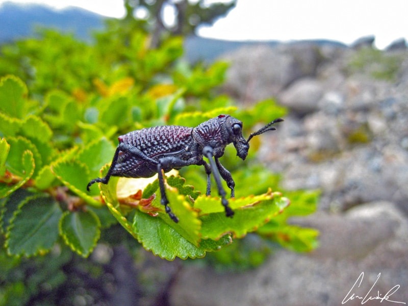
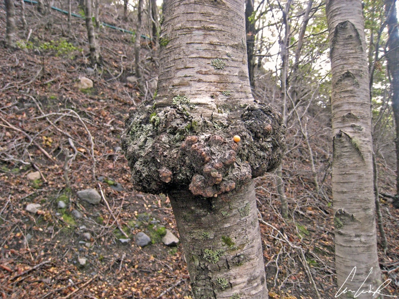
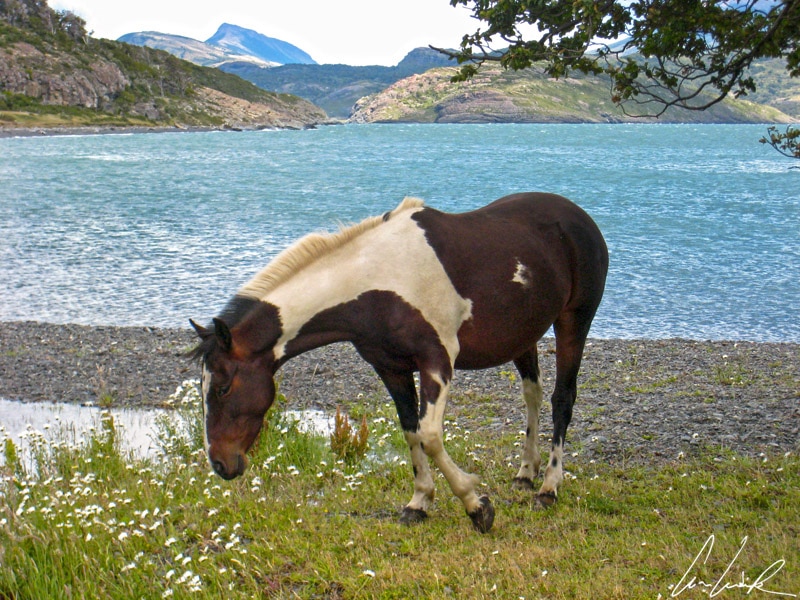
The path leading to the Serrano Glacier is lined with blooming shrubs full of colorful berries: Murtilla (Chilean Guava) whose strawberry-flavored fruit is used for the production of the strawberry aroma, Frutilla del Diablo (wild strawberry) which is inedible or Magellan’s Fuschia. A strange insect peacefully hidden in deep and thick vegetation is watching us. Many trees of the genus Nothofagus (a family of the beech trees) host Cyttaria (Llao-llao or Pan de Indio), an edible fruit-like fungus (I did not taste it). These fungi form tumors (nodes) at the branches and trunks of infected trees. In response to this parasite, the tree develops a strong very decorative outgrowth often used in crafts. These tumors form a rounded, blistered woody shape and can reach impressive a circumference of up to 9 feet. We reach the shore to finish our journey to the Fjord Última Esperanza, enjoying some of the majestic landscapes of the fjord lined with estancia where horses graze freely along the water… If there were only one sentence to summarize this discovery of Chilean Patagonia, I would choose the following, “The splendor of the landscape is in line with the legendary inhospitability of the place”.


This looks like such a calm and tranquil place! Must have been such a nice feeling to be faced with the turquoise lake after the hike. I’m too lazy for hiking but if I’m rewarded with such sights, I might do it. Thank you for sharing this beautiful place.
The color of this lake is unreal. There are many good viewing spots along the road where you see both the lake and the mountains in the background. One of the best sights you can see in the park without having to hike 😉
Beautiful place and amazing photos. I find the information very useful!
Thank you 🙂 I was amazed by this place, it was simply overwhelming to experience all this beauty in just one spot together !
Chile really is such a beautiful country. I can wait to visit. Your description and photos of Torres Del Plaine are amazing. It just makes me want to book a trip right now. The colors of the blues really are fantastic and so many different shades. Thank you so much for sharing.
Arguably the most famous park in all of South America 🙂 the Torres del Paine National Park is a true mecca for those looking to experience the rugged nature of Chilean Patagonia !
OMG what stunning scenery. You did a great job at capturing the beauty of the Torres Del Paine! I wanna go there and meditate!
Visiting Torres del Paine National Park is definitively an adventure for your bucket list 🙂
Thank you so much for sharing a post about the land lost in the sea. How the lakes in the park take on a turquoise, emerald or milky color depending on their depth, the composition of the water, and the weather is interesting!
Torres del Paine National Park is one of the absolute highlights of a visit to Patagonia. The dramatic scenery of Torres del Paine is simply breath-taking and the colours of the lakes are incredibly stunning and beautiful !
Your pictures are quite stunning. There is nothing like being in a beautiful place on a day when the sky is so blue!
Thank you 🙂 This world famous park encompasses spectacular mountains, multi-colored lakes, glaciers, lots of wildlife and a magic touch that you will never understand unless you have been there.
Girl… these photos are everything! I didn’t make it down there on my first trip to Chile, but this is absolutely at the top of my list for next time… Hopefully soon! Stunning!
Southern Patagonia has long lured travelers to what is very nearly the end of the world with its storied peaks carved by age-old glaciers and spellbinding landscapes ! Visiting this region is definitively an adventure for your bucket list 🙂
Chile is such a magnificent country. You reconfirmed that fact with your amazing photos and detailed descriptions. I can’t wait to go one day.
Chile is an awesome destination – a lot of outdoor adventures, but also beautiful cities to explore the culture (such as Valparaiso). Perfect mix for all interests 🙂
Oh wow this is beyond gorgeous and 100% on our bucket list. It looks so peaceful and crowd-free. Your photos are so stunning.
It’s worth exploring the awe-inspiring Torres del Paine National Park !
Oh my goodness, your photos are breathtaking! This place looks so dreamy 🙂
Thank you 🙂 Chilean Patagonia is, like Chile, a slender affair: wherever you go, you are close to the ocean as well as the Andes.
Thats a lot of varied landscapes you get to see. My favorite is the glacier pic. Looks cool with that ice block floating
An amazing voyage amongst eternal ice and drowsy nature ! 😉
WOW! It looks really amazing! It goes on my bucket list right now, for sure!
Thank you 🙂 It’s worth exploring the awe-inspiring Torres del Paine National Park !
The landscape looks otherworldly. The different shades of blue your photos capture look absolutely amazing.
I was amazed by this place, it was simply overwhelming to experience all this beauty in just one spot together !
This is beautiful!! I want to go to Patagonia so badly. Too many places and so little time!
I fully agree with you ! As an avid outdoors enthusiast and world traveler I’m determined to discover the remote corner of the planet. The more I see, the more I want to see. The more I explore, the more I appreciate how fortunate I am to be able to do so 🙂
Amazing colours and beautiful landscape. The title of the post is really apt. Wish I could be here. Loved the pics.
As for the ones who do not take pictures: you will never forget the hundreds of colours of the world’s most southerly park 🙂
Wow, that turquoise! Absolutely stunning!
What a sight it must have been visiting this lake. Amazing!
The color is unbelievable even with no sun ! Lago Pehoe is without a doubt, one of the most beautiful places of the Park 🙂
The nature looks so beautiful here! Would love to spend some time exploring Chile too!
A very interesting and informative page. I am particularly interested in the name Lake Grey. OK, I have been there myself and the water is i fact greyish. But still, the lake is called Lago Grey in Spanish. If the colour of the lake has given it this name, why not Lago Gris?
¿Por qué Lago Grey es gris? This is a very good question! Lago Grey draws its name from its water color. The lake is dark grey thanks to the sediment that leaches into the water from the glacier itself. I agree with you, the name should be Lago Gris 🙂